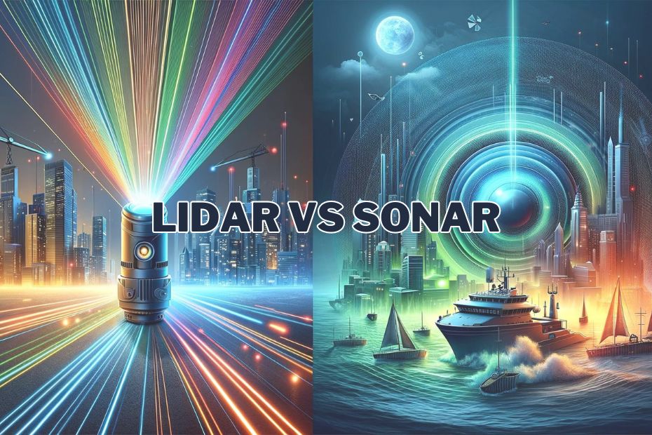
Lidar (Light Detection and Ranging) and Sonar (Sound Navigation and Ranging) are two powerful technologies used across various industries for mapping, detection, and navigation. Both technologies offer unique capabilities, yet they operate on fundamentally different principles: Lidar uses light, while Sonar uses sound. The question of whether Lidar is better than Sonar is often raised when selecting the most suitable technology for specific applications. The answer, however, depends on a range of factors, including the environment in which the technology will be used, the required level of accuracy, and the cost considerations.
What is Lidar?
Lidar, which stands for Light Detection and Ranging, is a technology that uses pulses of laser light to measure distances. It works by emitting light pulses from a sensor and calculating the time it takes for the light to bounce back after hitting an object. The time taken is then used to calculate the distance between the sensor and the object. By repeating this process rapidly, Lidar can create highly detailed, three-dimensional maps of its surroundings.
How Lidar Works: Lidar systems typically consist of three main components:
- Laser – Emits pulses of light at a high frequency.
- Scanner and optics – These components are responsible for directing the laser beam towards the target.
- Receiver – Captures the reflected light pulses and calculates the distance by measuring the time of flight (how long it took for the light to return).
This process happens at incredibly high speeds, allowing Lidar systems to generate vast amounts of data in a short time. The precision of Lidar technology allows it to detect even small objects and create detailed 3D point clouds, which are essential for applications that require accurate spatial data.
Key Advantages of Lidar:
- High resolution: Lidar can generate highly detailed 3D maps, making it ideal for mapping landscapes, urban environments, or complex structures.
- Speed: Lidar systems are capable of scanning large areas quickly, which is beneficial for industries like urban planning and forestry.
- Accuracy: Lidar provides accurate distance measurements, with some systems capable of measuring distances with millimeter precision.
Applications of Lidar: Lidar has become indispensable in a variety of fields. Some of the most notable applications include:
- Autonomous vehicles: Lidar is crucial in self-driving cars for real-time 3D mapping and object detection. The technology helps vehicles navigate by detecting obstacles and calculating distances with extreme precision.
- Geospatial mapping: Lidar is extensively used in surveying and cartography to create accurate topographical maps, especially in areas where traditional methods may be inefficient.
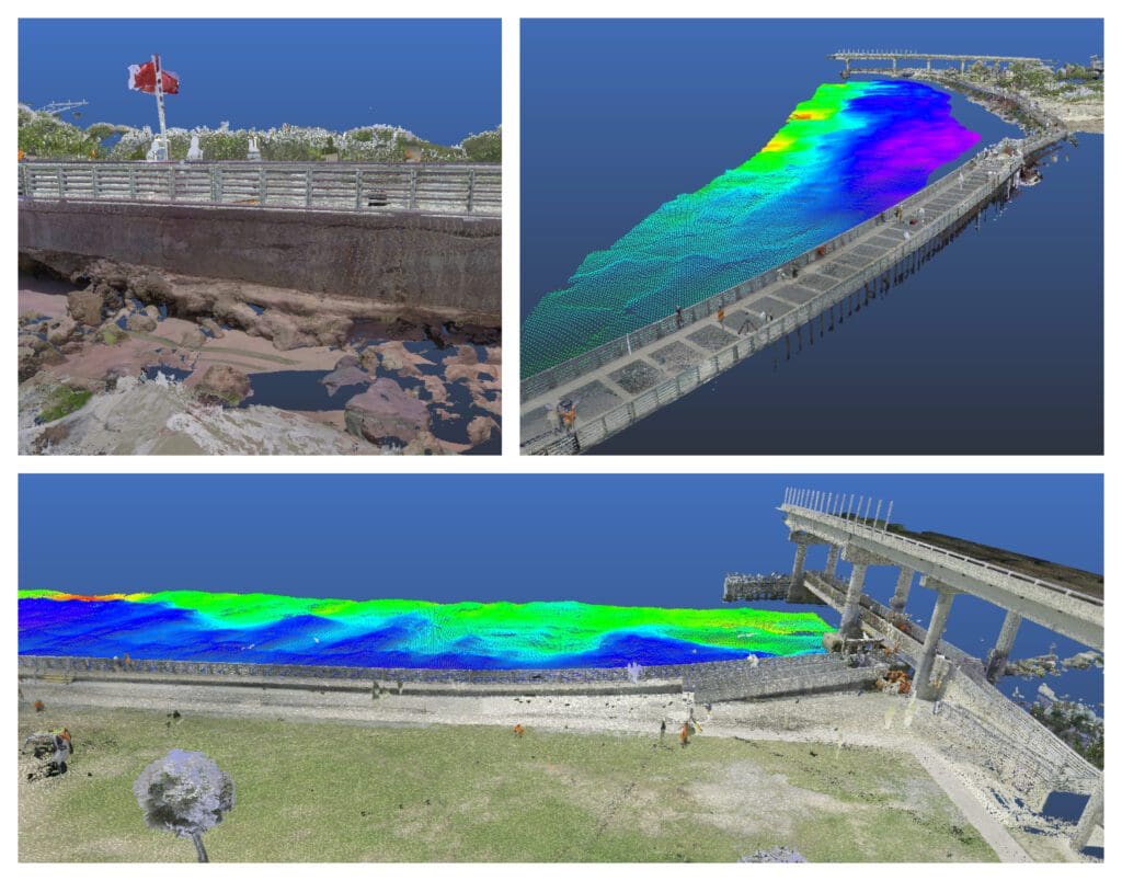
- Environmental monitoring: Lidar is useful for studying forests, coastal zones, and disaster areas. Its ability to penetrate vegetation can help researchers monitor deforestation or assess damage from natural disasters like wildfires and landslides.
Lidar’s strengths are most evident in above-ground applications where speed, accuracy, and the ability to capture fine details are paramount. However, its performance can be significantly hindered in certain environments, particularly underwater, where light is absorbed or scattered. This is where Sonar often becomes the preferred technology, as it uses sound waves instead of light, which behave differently in such conditions.

What is Sonar?
Sonar, which stands for Sound Navigation and Ranging, operates on a fundamentally different principle compared to Lidar. Instead of using light, Sonar relies on sound waves to detect objects and measure distances. It is particularly useful in environments where light cannot penetrate, such as underwater. Sonar works by emitting sound pulses, or “pings,” and then measuring how long it takes for the sound waves to bounce back after striking an object.
How Sonar Works: Sonar systems consist of the following key components:
- Transmitter – Generates and sends sound waves, typically in the form of pulses or pings.
- Receiver – Listens for the return signal after it has bounced off an object.
- Processor – Analyzes the time delay between sending the pulse and receiving the echo, calculating the distance to the object.
Sonar technology takes advantage of the fact that sound waves travel well through water, making it an essential tool for underwater navigation, exploration, and detection. The speed of sound in water is much faster than in air, and the system can determine an object’s distance by using the time difference between sending and receiving the sound wave.
Key Advantages of Sonar:
- Ideal for underwater environments: Sonar is most effective in water because sound waves travel efficiently through this medium, unlike light, which is quickly absorbed or scattered.
- Range: Sonar can detect objects at considerable distances underwater, making it valuable for deep-sea exploration.
- Penetration: Sonar waves can penetrate various water conditions, such as murky or dark environments where other technologies, like Lidar or optical cameras, would struggle.
Applications of Sonar: Sonar has been a crucial technology in several industries for many decades. Some of its primary applications include:
- Marine navigation: Sonar is widely used for navigating ships and submarines by providing data about underwater terrain and detecting obstacles.
- Underwater exploration: Deep-sea explorers use Sonar to map the ocean floor and locate objects submerged at great depths, including shipwrecks and underwater ecosystems.
- Fishing: Sonar is essential for detecting schools of fish, making it a valuable tool for commercial and recreational fishing.
- Military applications: Sonar plays a vital role in naval defense, especially in detecting submarines, torpedoes, and mines in underwater combat scenarios.
While Sonar excels in underwater environments, it is not as effective in air, where sound waves do not travel as efficiently. This makes Sonar unsuitable for tasks like aerial mapping or applications that require high-resolution data, where Lidar is the superior choice. Understanding the strengths of Sonar is key to determining when to use it over Lidar.

Key Differences Between Lidar and Sonar
While both Lidar and Sonar are used for measuring distances and detecting objects, their fundamental differences in how they operate, the environments in which they excel, and their overall effectiveness in various applications set them apart. Understanding these key distinctions is essential for determining whether Lidar or Sonar is better suited for a particular task.
Medium of Operation: Light vs. Sound
One of the most significant differences between Lidar and Sonar is the medium through which they operate. Lidar uses light waves, while Sonar uses sound waves. This difference in medium has several implications:
- Lidar operates by emitting light pulses, which travel well in air and can create highly accurate and detailed 3D maps of environments. However, light waves are easily absorbed or scattered in water, limiting the effectiveness of Lidar in aquatic settings.
- Sonar, on the other hand, uses sound waves, which travel efficiently through water. Sound can penetrate deep into the ocean, even in murky or dark conditions, making Sonar ideal for underwater exploration and navigation. However, sound waves are less effective in air, limiting the use of Sonar in land-based or aerial applications.
The choice between Lidar and Sonar is heavily influenced by the environment in which the technology will be used. If the task involves air or space, Lidar is typically the better choice. For underwater tasks, Sonar is the clear winner due to its ability to navigate through water.
Range and Depth Capabilities
The range and depth at which each technology operates also differs significantly:
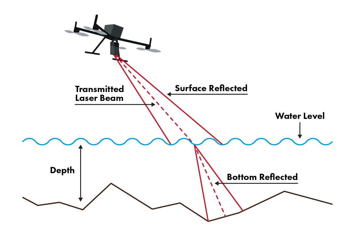
- Lidar is highly effective at scanning large areas quickly and can cover significant distances in open environments such as forests, cities, or roads. However, its ability to penetrate water is severely limited due to the absorption of light by water molecules. For example, Lidar can only penetrate shallow bodies of water, making it unsuitable for deep-sea applications.
- Sonar is specifically designed for use in water and can detect objects at much greater depths than Lidar. Deep-sea exploration and naval applications rely on Sonar because sound waves can travel long distances in water. This makes Sonar the go-to technology for mapping the ocean floor or detecting objects in deep underwater environments.
Accuracy and Resolution
The accuracy and resolution of data produced by each technology vary based on the application:
- Lidar provides incredibly high resolution and precision, especially in above-ground environments. It can create detailed 3D maps with millimeter-level accuracy, making it indispensable for tasks like surveying, autonomous vehicle navigation, and architectural design. Lidar’s ability to detect fine details in its surroundings is one of its strongest advantages.
- Sonar tends to have lower resolution compared to Lidar. While Sonar is highly effective for detecting large objects or mapping general underwater topography, it does not offer the same level of detail that Lidar provides. This limitation is often a trade-off when using Sonar for tasks that prioritize range and depth over high-resolution imagery.
Speed of Data Collection
Another key factor in comparing Lidar and Sonar is the speed of data collection:
- Lidar systems can collect large amounts of data rapidly, making them highly efficient for tasks that require fast and real-time mapping, such as drone-based surveying or autonomous driving systems. The high speed at which Lidar processes data gives it a significant edge in situations where time is critical.
- Sonar typically collects data at a slower rate, particularly when conducting deep-sea scans or underwater explorations. The process of sending out sound pulses and waiting for echoes can be time-consuming, especially when working at great depths. As a result, Sonar may not be ideal for scenarios where real-time data is required.
Lidar vs. Sonar
| Feature | Lidar | Sonar |
|---|---|---|
| Medium | Light waves | Sound waves |
| Best Environment | Air and above-ground environments | Water and underwater environments |
| Range | Limited in water, high range in air | Excellent for deep-water detection |
| Resolution | High-resolution, detailed maps | Lower resolution, suitable for general detection |
| Speed of Data Collection | Fast | Slower, especially in deep water |
| Applications | Autonomous vehicles, geospatial mapping | Marine navigation, deep-sea exploration |
These fundamental differences highlight that Lidar and Sonar are suited to vastly different environments and tasks. Therefore, the decision of whether Lidar is better than Sonar ultimately depends on the specific use case, the environment, and the required level of detail and accuracy.

Lidar vs Sonar: Which is Better for Different Use Cases?
While Lidar and Sonar both serve the purpose of detecting objects and measuring distances, their differences in medium, range, resolution, and environment make each more suitable for specific applications. Determining whether Lidar is better than Sonar depends on the context in which they are being used.
Lidar for Aerial Mapping and Autonomous Vehicles
Lidar has proven to be a superior technology for aerial mapping and autonomous vehicles, thanks to its ability to generate high-resolution 3D maps quickly and accurately. For example:
- Aerial mapping: Lidar is commonly used in geographic information systems (GIS) for terrain modeling, urban planning, and forestry management. Its high accuracy and fast data collection allow users to map large areas with fine detail. Lidar’s ability to penetrate thin vegetation also makes it ideal for creating digital elevation models (DEMs), even in forested regions.
- Autonomous vehicles: Self-driving cars rely heavily on Lidar to detect obstacles, pedestrians, and other vehicles. The ability of Lidar to scan the surroundings in real time, providing 360-degree views, ensures that autonomous vehicles can navigate safely in complex urban environments. Additionally, Lidar’s high precision allows it to detect objects as small as a curb or a pedestrian crossing the street, something Sonar cannot achieve with the same level of detail.
Sonar for Marine and Underwater Exploration
Sonar is undeniably better for marine and underwater exploration, where light-based technologies like Lidar cannot function effectively due to the absorption of light in water. Sonar’s ability to use sound waves to detect objects in deep, murky waters makes it the preferred choice for underwater tasks. Some notable use cases include:
- Marine navigation: Ships and submarines depend on Sonar to navigate safely through waters, detect obstacles, and avoid collisions. The range and depth capabilities of Sonar make it ideal for identifying underwater hazards, even in poor visibility conditions.
- Underwater exploration: Sonar is extensively used for mapping the ocean floor and discovering submerged objects, such as shipwrecks or underwater structures. Deep-sea expeditions rely on Sonar to gather data from areas that are too deep for Lidar or other light-based technologies to reach.
Environmental Monitoring and Research
Both Lidar and Sonar have valuable roles in environmental monitoring and research, but their effectiveness depends on the specific environment being studied:
- Lidar is better suited for monitoring land-based ecosystems. For instance, it can be used to measure forest canopy height, monitor deforestation, and track changes in urban landscapes. Lidar’s ability to create detailed, high-resolution maps helps researchers understand the physical environment and detect subtle changes over time.
- Sonar excels in aquatic environments. Marine biologists and oceanographers use Sonar to study underwater ecosystems, map coral reefs, and monitor marine species. Sonar’s capacity to function in deep, turbid waters makes it a vital tool for conducting research in the ocean, where Lidar’s effectiveness is limited.
Case Study: Lidar in Autonomous Vehicles vs. Sonar in Submarine Navigation
In the realm of autonomous vehicles, Lidar has become the preferred technology due to its ability to create real-time 3D maps of road environments. For example, companies like Google’s Waymo and Tesla incorporate Lidar systems to enhance the safety and navigation of their self-driving cars. Lidar’s high resolution allows vehicles to detect obstacles with millimeter precision, ensuring that even the smallest road hazards are identified.
In contrast, Sonar is indispensable for submarines and other underwater vehicles. Submarines rely on Sonar to navigate in deep waters, where light cannot penetrate. The ability of Sonar to detect underwater objects, such as mines, other submarines, and underwater terrain, makes it a critical technology for the military and scientific expeditions. While Lidar would fail to perform in such depths, Sonar thrives, ensuring safe navigation in environments where visibility is zero.
Comparison Chart: Use Cases of Lidar vs Sonar
| Use Case | Lidar | Sonar |
|---|---|---|
| Aerial mapping | High resolution, fast data collection | Not suitable |
| Autonomous vehicles | Real-time 3D mapping, accurate detection | Not used |
| Marine navigation | Limited effectiveness in water | Ideal for detecting underwater obstacles |
| Underwater exploration | Ineffective due to light absorption | Excellent for mapping the ocean floor |
| Environmental monitoring | Best for land-based environments | Best for aquatic environments |
Ultimately, the decision to use Lidar or Sonar depends on the environment and the specific needs of the task. For aerial and land-based applications, Lidar is the better option due to its accuracy and speed. However, for underwater exploration and navigation, Sonar remains unrivaled.