Lidar and Radar have become pivotal technologies across various industries, particularly in fields such as autonomous driving, aviation, defense, and environmental monitoring. The question of whether Lidar is better than Radar often arises due to the distinct advantages each technology offers. Both serve the fundamental purpose of detecting and mapping objects in space, but they operate using very different methods—Lidar uses laser light, while Radar relies on radio waves. These differences in operation lead to variations in performance, accuracy, cost, and suitability for different conditions.
Lidar, short for Light Detection and Ranging, is a remote sensing technology that uses laser pulses to measure distances between a sensor and objects in its surroundings. By emitting thousands of laser pulses per second and measuring the time it takes for each pulse to reflect back, Lidar can create highly accurate, three-dimensional (3D) maps of the environment. This technology has gained widespread attention, particularly in the fields of autonomous driving and environmental monitoring, due to its ability to produce precise spatial data.
How Lidar Works:
Lidar operates by sending out laser beams—usually in the infrared or visible spectrum—toward a target. When these beams hit an object, they bounce back to the sensor, and the time taken for this round trip is recorded. This time measurement, combined with the speed of light, allows the system to calculate the distance between the sensor and the object with remarkable accuracy. Since Lidar systems emit thousands of pulses per second, they are able to create detailed 3D models of their environment.
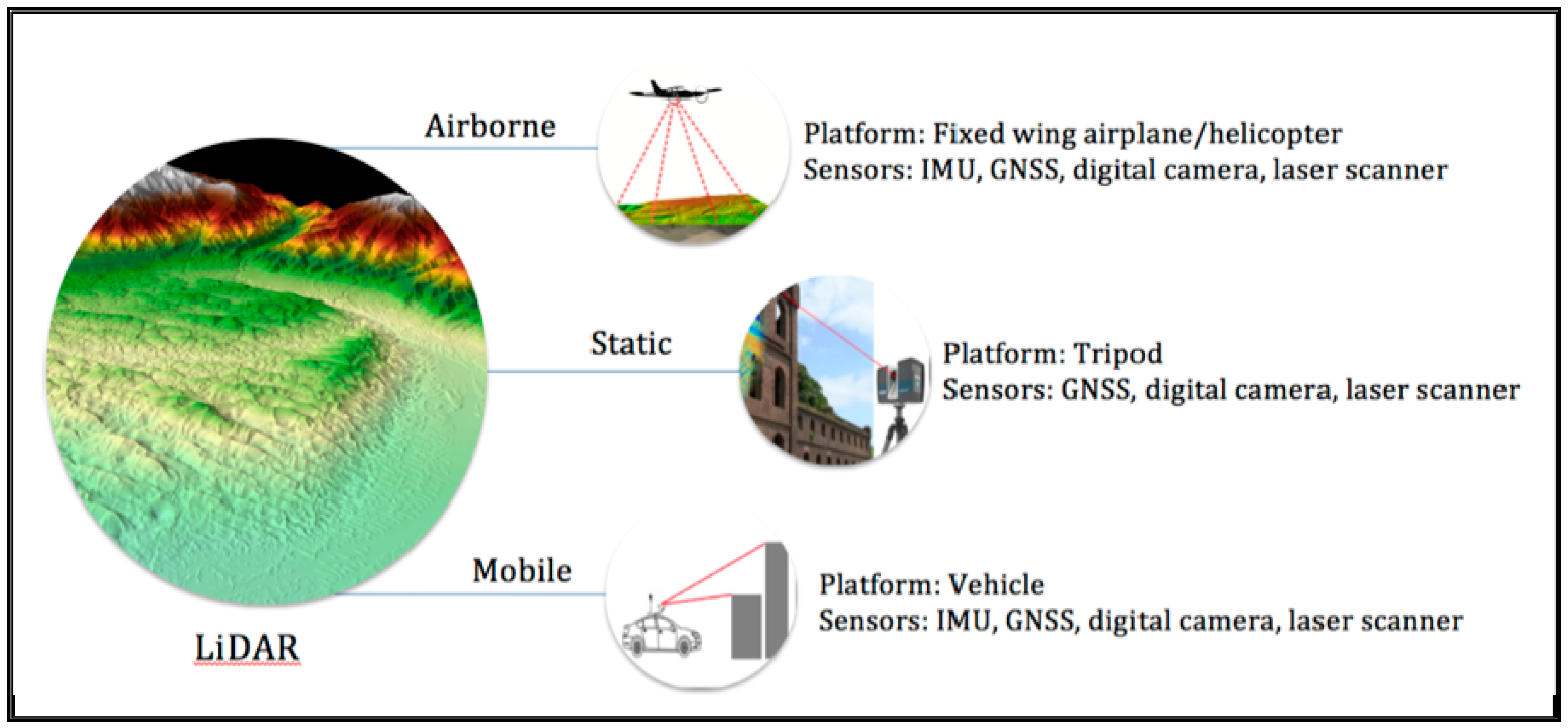
Lidar systems typically consist of three main components:
- Laser: Generates light pulses.
- Scanner: Directs the laser pulses and gathers the return signals.
- GPS Receiver: Records the exact position of the sensor to ensure spatial accuracy.
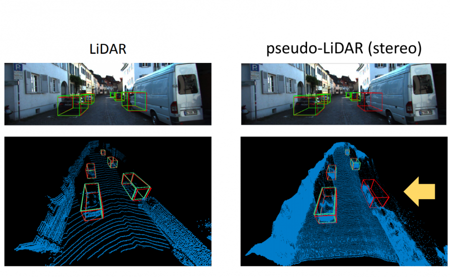
The data from these components are processed to create what’s called a “point cloud,” a set of data points in a 3D coordinate system that represents the surfaces of objects.
Applications of Lidar:
Lidar is widely used across many industries:
- Autonomous Vehicles: Lidar enables self-driving cars to perceive their environment, detect obstacles, and make real-time navigation decisions.
- Environmental Monitoring: Lidar is employed in creating detailed topographic maps, particularly for forest management, flood modeling, and coastal erosion studies.
- Urban Planning and Infrastructure: Lidar is used for generating accurate 3D models of cities, aiding in construction and infrastructure development.
- Archaeology: Lidar has been instrumental in uncovering hidden structures beneath dense forests or mountainous terrains, providing archaeologists with detailed mapping of landscapes without excavation.
Advantages of Lidar:
Lidar offers several advantages over other remote sensing technologies, such as:
- High Accuracy: Lidar is known for its superior accuracy, especially in creating detailed 3D maps of close-range environments. It can detect objects within a few centimeters of precision.
- 3D Mapping Capability: Unlike Radar, which often provides only two-dimensional data, Lidar excels in producing detailed 3D maps.
- Real-Time Data Collection: In dynamic applications, such as autonomous driving, Lidar collects data in real time, allowing vehicles to react quickly to changes in their environment.
However, it is important to note that despite these advantages, Lidar has its limitations. Its performance in adverse weather conditions, such as heavy fog or rain, can be significantly impacted. Additionally, the high cost of Lidar systems may be prohibitive for some applications, especially when compared to Radar.
Lidar is a highly effective technology in scenarios that require high-precision mapping and real-time spatial awareness. Its ability to create detailed 3D models makes it indispensable in certain industries, though its cost and limitations in weather conditions should also be considered when evaluating its overall suitability.

What is Radar?
Radar, or Radio Detection and Ranging, is a technology that uses radio waves to detect and locate objects. Unlike Lidar, which employs laser light, Radar emits radio waves and measures the time it takes for them to bounce back after hitting an object. This process allows Radar to determine the distance, speed, and sometimes even the shape of an object. Radar is an older technology than Lidar, but it continues to be widely used in several critical industries due to its reliability in various conditions.
How Radar Works:
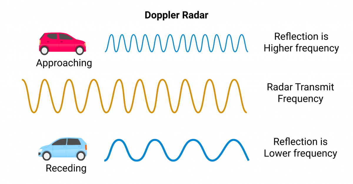
Radar operates by transmitting radio waves, typically in the microwave frequency range, from an antenna. When these waves hit an object, part of the signal is reflected back toward the radar system, which then calculates the time delay between transmission and reception. This time delay is used to determine the distance to the object. Additionally, by analyzing changes in the frequency of the reflected waves (a phenomenon known as the Doppler effect), Radar systems can calculate the speed of moving objects.
Radar systems are generally composed of the following components:
- Transmitter: Generates radio waves and sends them through an antenna.
- Receiver: Detects the signals that bounce back after hitting objects.
- Processor: Analyzes the reflected signals to calculate the distance, speed, and sometimes the size or shape of objects.
While Radar does not provide the same level of detail as Lidar when it comes to creating 3D models, it excels at detecting objects over long distances and in poor visibility conditions, such as during heavy rain, fog, or snow.
Applications of Radar:
Radar has proven to be highly versatile and is used in a wide range of fields:
- Aviation and Air Traffic Control: Radar is essential for tracking aircraft, ensuring safe distances between planes, and managing busy airspace.
- Weather Monitoring: Meteorologists rely on Radar to monitor weather patterns, track storms, and predict rainfall. Doppler Radar, in particular, helps in detecting the speed and direction of precipitation.
- Military and Defense: Radar plays a crucial role in detecting and tracking enemy aircraft, ships, and missiles. It is also used in missile guidance systems.
- Maritime Navigation: Ships use Radar to detect other vessels and land masses, especially in poor weather or at night.
Advantages of Radar:
Radar offers several unique advantages:
- Long-Range Detection: Radar can detect objects at much greater distances than Lidar. This makes it ideal for applications like air traffic control and military surveillance.
- All-Weather Capability: Radar is less affected by environmental conditions like fog, rain, and dust. It can reliably detect objects in almost any weather condition, making it highly effective for aviation and maritime use.
- Cost-Effective: In many cases, Radar systems are less expensive to deploy than Lidar systems, especially in large-scale applications like weather monitoring and traffic control.
Radar’s ability to work over long distances and through challenging weather conditions makes it indispensable in scenarios where reliability and range are more important than detailed 3D mapping. However, it falls short when it comes to providing the high-resolution, 3D data that Lidar excels at producing.
Radar is a powerful technology that is well-suited for long-range detection and harsh weather environments. While it lacks the high precision and detailed spatial awareness of Lidar, it remains an essential tool in many industries due to its versatility, lower cost, and robustness in adverse conditions.
.jpg)
Key Differences Between Lidar and Radar
While both Lidar and Radar are widely used for object detection and environmental mapping, they differ significantly in how they operate and the applications they are best suited for. These factors include accuracy, range, cost, environmental conditions, 3D mapping capability, and energy consumption.
Accuracy
Lidar is generally regarded as more accurate than Radar, especially in terms of mapping and detecting small objects. The laser pulses used in Lidar systems are extremely precise, allowing the technology to measure distances within a few centimeters or even millimeters. This high degree of accuracy makes Lidar ideal for applications like autonomous vehicles and urban planning, where detailed 3D models of the environment are necessary for safe navigation and decision-making.
Radar, on the other hand, is less accurate when it comes to detecting small or closely spaced objects. The longer wavelength of radio waves means that Radar can have difficulty distinguishing between objects that are very close together. However, this doesn’t mean Radar is ineffective—far from it. Radar’s strength lies in its ability to detect larger objects over long distances and in various weather conditions, making it invaluable for applications like aviation, maritime navigation, and weather monitoring, where precision mapping isn’t the primary concern.
In short:
- Lidar provides superior accuracy in short-range detection and 3D mapping.
- Radar excels in long-range detection but lacks the precision of Lidar for detailed spatial data.
Range
The operational range of a sensing technology is crucial depending on the application. Lidar typically performs best at short to medium ranges, usually up to 200-300 meters. Beyond this range, the effectiveness of Lidar starts to diminish, particularly in poor visibility or challenging weather conditions.
Radar, on the other hand, is known for its long-range capabilities. Radar can detect objects many kilometers away, making it the preferred choice for aviation, military, and weather forecasting. Long-range detection is critical in these fields, where early detection and tracking of objects or weather patterns are essential for safety and planning.
Summary of range:
- Lidar is best suited for short to medium-range detection (up to 200-300 meters).
- Radar can detect objects at long distances, often several kilometers away.
Cost
Cost is a significant factor when deciding between Lidar and Radar. Historically, Lidar systems have been more expensive to produce and implement than Radar systems, largely due to the complexity of the laser and scanning technology involved. The cost of Lidar sensors can be prohibitive for large-scale deployment, especially in industries like automotive manufacturing, where cost efficiency is critical.
Radar systems are generally more cost-effective, especially for applications that require long-range detection over large areas. For example, weather monitoring systems or military surveillance systems that cover vast distances can be implemented more affordably with Radar. As Lidar technology advances and production costs decrease, this gap is narrowing, but for now, Radar remains the more budget-friendly option.
Cost comparison:
- Lidar is more expensive due to its advanced components and higher accuracy.
- Radar is more cost-effective, especially for long-range applications.
Environmental Conditions
One of the most critical distinctions between Lidar and Radar is how they perform under different environmental conditions. Lidar, which relies on light, is highly sensitive to weather conditions like fog, rain, snow, or dust. In these situations, the laser pulses can be scattered or absorbed, leading to reduced accuracy and range. For instance, in heavy fog, Lidar’s ability to map objects might be severely limited, posing challenges for its use in autonomous vehicles during poor weather.
Radar, on the other hand, is far less affected by environmental conditions. Since Radar uses radio waves, which have much longer wavelengths than light, it can penetrate through fog, rain, and even dust storms. This makes Radar a more reliable technology for applications that require continuous operation in all weather conditions, such as aviation, maritime navigation, and military surveillance.
Environmental performance:
- Lidar is susceptible to performance issues in adverse weather conditions.
- Radar remains highly effective in challenging weather environments, providing reliable detection.
3D Mapping
One of Lidar’s standout features is its ability to create high-resolution 3D maps. This capability stems from the precision of its laser pulses, which can measure even the smallest variations in distance to create detailed models of the surrounding environment. Lidar’s 3D mapping capability makes it the preferred choice for industries that require detailed spatial data, such as autonomous vehicles, urban planning, and environmental monitoring.
Radar, while effective for detecting objects and tracking their movement, does not produce the same level of detail as Lidar. Radar systems are generally better at providing 2D data and are used more for tracking the position and movement of objects than for creating detailed environmental maps.
3D mapping:
- Lidar excels in creating high-resolution 3D maps.
- Radar provides 2D tracking but lacks the spatial detail needed for 3D modeling.
Energy Consumption
Energy efficiency is another important consideration when comparing Lidar and Radar. In many cases, Lidar systems consume more energy than Radar, due to the high power required to emit and receive laser pulses. This can be a drawback in applications where energy consumption needs to be minimized, such as in battery-powered autonomous vehicles.
Radar systems are generally more energy-efficient, particularly in long-range applications. Radar’s use of radio waves, which require less power to emit and receive, makes it a more suitable option for continuous monitoring over large areas.
Energy comparison:
- Lidar tends to consume more energy, especially in power-intensive applications like autonomous vehicles.
- Radar is generally more energy-efficient, making it ideal for long-term, large-scale monitoring.
When evaluating Lidar vs. Radar, it is essential to consider the specific needs of the application. Lidar excels in high-precision 3D mapping, making it the technology of choice for autonomous vehicles and other applications requiring detailed spatial data. Radar, on the other hand, is superior in long-range detection and adverse weather conditions, making it a better fit for industries like aviation, defense, and weather monitoring. Both technologies have their strengths and weaknesses, and choosing between them depends largely on the priorities of accuracy, range, cost, and environmental reliability.

When Lidar is Better
Lidar’s ability to create precise, high-resolution 3D maps makes it highly effective in several specific use cases. When accuracy and detailed environmental awareness are critical, Lidar tends to outperform Radar, despite its limitations in range and weather resilience. Below are some of the key scenarios where Lidar proves to be the better technology.
Autonomous Vehicles
One of the most prominent applications of Lidar technology is in autonomous driving. Self-driving cars rely on sensors to perceive their surroundings, and Lidar’s ability to create detailed, real-time 3D maps of the environment is essential for safe navigation. Lidar allows autonomous vehicles to:
- Detect and map objects such as pedestrians, other vehicles, and road signs.
- Create a highly accurate representation of the surroundings, down to the centimeter.
- Make real-time decisions based on the immediate environment.
For example, Waymo, a leading company in the autonomous vehicle industry, has integrated Lidar systems into its vehicles to provide a 360-degree view of the surroundings, ensuring that the car can detect objects from all directions. While some autonomous vehicle manufacturers, such as Tesla, rely on camera and radar systems, Lidar remains the preferred technology for companies that prioritize precise, real-time environmental mapping.
Urban Planning and Infrastructure Development
Lidar is increasingly being used in urban planning and infrastructure development. Its high-resolution mapping capabilities allow planners to:
- Create detailed models of cities and landscapes, which are critical for planning new buildings, roads, and other infrastructure.
- Monitor changes in urban environments over time, such as erosion, construction progress, or population growth.
- Analyze potential impacts of infrastructure projects on the environment and surrounding communities.
Case Study: New York City In recent years, New York City employed Lidar technology to map the entire city in 3D. This project allowed city planners to gain precise insights into building heights, roof shapes, and vegetation cover. The Lidar data is being used to improve city services, optimize energy consumption in buildings, and better prepare for flooding and other natural disasters.
Surveying and Topographic Mapping
Another important use case for Lidar is in land surveying and topographic mapping. Lidar’s ability to measure the precise distance to the Earth’s surface allows for the creation of detailed elevation models. Surveyors use Lidar to:
- Create digital elevation models (DEMs) that represent the terrain with high accuracy.
- Map difficult-to-reach or dangerous areas, such as mountainous regions or dense forests.
- Track changes in the landscape over time, such as erosion or deforestation.
This is especially valuable in industries such as mining, forestry, and environmental monitoring. Forestry management relies on Lidar to assess forest density, measure tree heights, and evaluate the health of ecosystems. In mining, Lidar is used to map underground tunnels and ensure the safety of operations.
Environmental Monitoring
Lidar is a critical tool for environmental scientists and ecologists who need to monitor natural habitats and study environmental changes over time. For instance:
- Coastal erosion studies use Lidar to monitor shorelines and predict future erosion patterns.
- Forest management uses Lidar to assess tree health and monitor forest growth and loss.
- Flood mapping projects employ Lidar to create detailed terrain models that help predict water flow during floods.
Case Study: Coastal Erosion Monitoring In California, Lidar has been used extensively to monitor the state’s coastline for signs of erosion. The data collected from Lidar scans has allowed researchers to create predictive models that estimate how rising sea levels will impact coastal communities, helping to guide policy decisions and infrastructure investments.
Archaeology
In the field of archaeology, Lidar has been groundbreaking, particularly in uncovering ancient structures that are hidden beneath dense vegetation or in difficult-to-reach areas. Lidar’s laser pulses can penetrate forest canopies, revealing the landscape underneath in great detail. Some of the most significant archaeological discoveries in recent years have been made with the help of Lidar:
- Mayan Ruins in Guatemala: Lidar was used to uncover a massive network of ancient Mayan cities hidden under the dense forests of Guatemala. The Lidar scans revealed over 60,000 previously undiscovered structures, revolutionizing archaeologists’ understanding of Mayan civilization.
- Cambodia’s Angkor Wat: Lidar has also been used to map the ancient city surrounding Angkor Wat in Cambodia, revealing the vast scale of the city’s infrastructure, much of which had been hidden by jungle growth.
Lidar is the superior choice in applications that demand high-precision, real-time 3D mapping. Industries such as autonomous vehicles, urban planning, surveying, environmental monitoring, and archaeology have embraced Lidar for its unparalleled accuracy and ability to produce detailed spatial data. While Lidar has limitations, particularly in range and weather resilience, it excels in any situation where detail and precision are paramount.