Photogrammetry is an essential technology that has transformed how engineering projects are planned, executed, and monitored. By using photographs to capture measurements and create 3D models, photogrammetry offers engineers a precise and efficient way to gather data. In an era where accuracy and cost-efficiency are paramount, this method stands out as a valuable tool across various fields of engineering. Its applications range from land surveying to structural analysis, offering solutions that reduce time and effort while enhancing precision.
What Is Photogrammetry and How Does It Work?
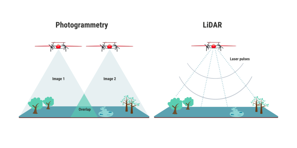
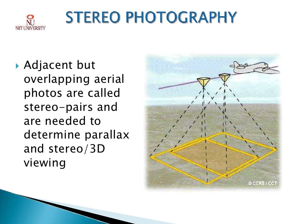
Photogrammetry is a technique that captures measurements from photographs to create detailed 3D models or maps of physical spaces. The process relies on multiple overlapping images taken from different angles to estimate distances and dimensions within a scene. The result is highly accurate data that can be used for a range of applications in engineering.
There are several types of photogrammetry that engineers can use, including:
- Aerial Photogrammetry: This involves taking images from aircraft or drones to survey large areas such as cities, forests, or farmlands.
- Terrestrial Photogrammetry: This method uses ground-based cameras to capture details of buildings or terrain.
- Close-range Photogrammetry: Typically used for smaller objects or detailed structures, where the camera is placed near the subject.
The core principles behind photogrammetry are fairly straightforward:
- Image Acquisition: The first step involves taking multiple overlapping photos of the target area or structure.
- Triangulation: By comparing the positions of points on the same object across different images, software can calculate the exact location of those points in 3D space.
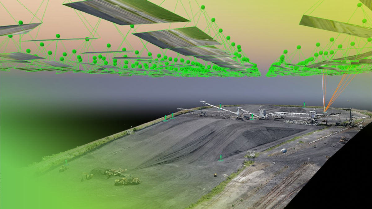
- 3D Reconstruction: Once all points are triangulated, they can be connected to create a 3D model of the surveyed area.
This entire process is supported by specialized tools and technologies, including high-resolution cameras, drones, and photogrammetry software like Agisoft Metashape, Pix4D, and DroneDeploy. These tools help engineers process the data efficiently, turning photos into detailed, scalable models.
Photogrammetry is particularly useful in projects that require precise data on large areas or difficult-to-reach places. By using aerial or drone-based methods, engineers can map an entire landscape without needing to step foot on it, which is both time-saving and safer for complex or hazardous environments.
In engineering, the accuracy of photogrammetric data can be measured in millimeters, making it suitable for structural assessments, topographical surveys, and construction planning.

Applications of Photogrammetry in Engineering
Photogrammetry’s ability to create highly accurate 3D models and maps has made it indispensable across various fields of engineering. Below, we explore some of the key applications of photogrammetry in different branches of engineering:
Structural Engineering
In structural engineering, photogrammetry is used to survey and monitor the integrity of buildings and infrastructure. Traditional methods of structural analysis often involve physical inspection, which can be time-consuming and may not capture all the critical details. With photogrammetry, engineers can create 3D models of structures to assess their conditions more efficiently and accurately.
- 3D Structural Modeling: Engineers can use photogrammetric models to analyze the geometry and detect any deformations in buildings. This is particularly useful for older buildings that require preservation or retrofitting.
- Monitoring Structural Health: Photogrammetry allows for regular, non-invasive monitoring of a structure’s condition. For instance, a building can be surveyed periodically to detect cracks, shifts, or other signs of wear that may not be visible to the naked eye.Case Study: In Italy, photogrammetry was used to monitor the Leaning Tower of Pisa, allowing engineers to understand the tilt dynamics and plan preservation efforts accordingly. Over several years, photogrammetric surveys have provided detailed data on the tower’s movement, helping to prevent further tilting.
Civil Engineering
Civil engineering has long been one of the most important fields benefiting from photogrammetry. Projects such as road construction, bridge building, and urban planning all rely heavily on accurate topographical data.
- Land Surveying and Topographical Mapping: Aerial photogrammetry is particularly useful in civil engineering projects. Engineers can capture high-resolution images of large areas, transforming them into detailed topographical maps that highlight elevation changes, terrain features, and natural obstacles.
- Integration with GIS (Geographic Information Systems): Photogrammetry data is often integrated with GIS to give civil engineers a comprehensive view of a site. This data is essential when planning infrastructure like highways, railways, and pipelines, ensuring that the routes chosen are efficient and safe.
- Infrastructure Projects: In large-scale civil engineering projects like the construction of bridges, tunnels, and roads, photogrammetry is used during both the planning and execution phases. The data helps engineers assess terrain, plan routes, and monitor construction progress.Example: The Panama Canal expansion project used photogrammetry to map the terrain surrounding the canal and plan new locks, allowing engineers to avoid delays and additional costs by identifying potential challenges early.
Construction Engineering
Photogrammetry has become a critical tool in construction engineering for everything from initial planning to ongoing project management.
- Planning and Design: Before breaking ground, photogrammetry can be used to create 3D models of the construction site, allowing engineers and architects to visualize the project and identify any potential issues related to the terrain or surrounding structures.
- Monitoring Construction Progress: Throughout the construction process, photogrammetry helps engineers track the progress of the build. Regular drone-based surveys capture the evolving site, which can then be compared with the original plans to ensure everything is proceeding as intended. This is particularly valuable for large-scale projects like skyscrapers, where accuracy and precision are crucial.
- Ensuring Accuracy: Photogrammetric data is precise enough to ensure that buildings are constructed according to the specifications, minimizing costly mistakes.Case Study: The construction of The Shard in London utilized photogrammetry to monitor progress and ensure the structural integrity of the building. Photogrammetric surveys allowed engineers to make adjustments in real time as the building’s complex, tapered design took shape.
Environmental Engineering
Environmental engineering relies on photogrammetry for assessing and managing natural resources, as well as monitoring environmental changes over time.
- Assessing Environmental Impact: Photogrammetry is used to create detailed maps of ecosystems, allowing engineers to assess how projects might impact the environment. For instance, before constructing a dam, engineers can map the river system and surrounding areas to understand the potential consequences for wildlife and plant life.
- Land Reclamation and Erosion Monitoring: Photogrammetry is also essential for land reclamation projects, where precise terrain data helps engineers restore land. Similarly, it plays a role in monitoring soil erosion in areas prone to landslides or degradation.Example: In Indonesia, photogrammetry was used to monitor coral reef health, allowing environmental engineers to assess the impact of tourism and propose methods to restore damaged sections.
Geotechnical Engineering
In geotechnical engineering, photogrammetry is critical for understanding terrain stability and assessing risks related to land use.
- Surveying for Stability: Engineers use photogrammetry to analyze terrain and identify potential risks, such as landslides or unstable slopes. By capturing detailed 3D data, geotechnical engineers can develop models that predict land movement and recommend stabilization methods.
- Identifying Deformation: Photogrammetry can detect even slight changes in the landscape, providing early warnings for potential disasters like sinkholes or slope failures.Case Study: After an earthquake in Japan, engineers used photogrammetry to assess land deformation and plan for rehabilitation efforts. By comparing pre- and post-earthquake data, engineers were able to quickly identify the areas that needed attention.
Photogrammetry is thus widely used in multiple engineering fields, contributing to more accurate, efficient, and safer project outcomes. Whether it’s used for land surveying, structural monitoring, or environmental assessments, photogrammetry offers engineers a versatile tool that enhances their ability to plan, design, and manage projects with a high degree of precision.

The Benefits of Using Photogrammetry in Engineering
The advantages of using photogrammetry in engineering projects are numerous, as this technology addresses key concerns such as accuracy, cost-efficiency, and safety. By leveraging the power of high-resolution imaging and advanced software, engineers can streamline their workflow, minimize risks, and achieve results that might be unattainable through traditional methods.
Cost-Efficiency
One of the most significant benefits of photogrammetry is its potential for cost reduction. Traditional surveying methods often require physical access to the site, which can be labor-intensive and expensive, especially in large-scale or remote projects. Photogrammetry, particularly when drones are used, significantly reduces the cost of data collection in several ways:
- Faster Data Collection: Photogrammetry allows for rapid image acquisition, especially in projects that involve vast areas of land. In a matter of hours, drones can capture hundreds of images that would take surveyors days or weeks to cover using manual methods.
- Reduced Manpower: Since much of the work is done through automation (such as drones or fixed camera setups), fewer people are needed on-site. This lowers labor costs and reduces the need for extended project timelines.Fact: According to a report by the American Society of Civil Engineers, using drones for photogrammetry can reduce survey costs by as much as 50%, especially in infrastructure projects where terrain complexity is a factor.
Increased Accuracy and Precision
Accuracy is a cornerstone of any engineering project, and photogrammetry excels in this area. The ability to create highly detailed 3D models allows engineers to spot issues that might go unnoticed using traditional surveying methods.
- Millimeter-Level Precision: Photogrammetry, when used with high-quality equipment and software, can achieve accuracy within millimeters. This level of precision is crucial for structural integrity assessments and infrastructure projects, where even the smallest miscalculation can lead to significant errors.
- Data Consistency: With photogrammetry, engineers can perform repeated surveys to ensure consistency over time. This is especially useful in projects where conditions change rapidly, such as construction sites or areas affected by erosion.Comparison: When compared to traditional methods such as GPS-based surveying, photogrammetry provides broader spatial coverage while maintaining a high degree of accuracy, particularly in difficult-to-reach areas.
Versatility Across Projects
Photogrammetry’s versatility makes it suitable for a wide range of engineering applications. It can be used for projects that span from small-scale site assessments to large, complex infrastructure builds.
- Adaptability: Whether it’s mapping an entire city using aerial photogrammetry or capturing the intricate details of a building facade with close-range photogrammetry, the technology can adapt to the needs of the project. This flexibility ensures that photogrammetry can be used for surveying, modeling, and monitoring across different industries.
- Multi-Scale Applications: Photogrammetry can be used at multiple scales—from large-scale urban planning to detailed architectural design. This adaptability allows engineers to switch between different perspectives, providing a comprehensive understanding of the site or structure in question.Example: In urban planning, photogrammetry has been used to create digital twins of cities, which allow engineers and architects to test different infrastructure designs in a virtual environment before implementing them in the real world.
Enhanced Safety
Safety is always a concern in engineering projects, especially when the terrain is hazardous or the structure being inspected is in disrepair. Photogrammetry provides a safer alternative by reducing the need for human presence in dangerous environments.
- Drones for Hazardous Areas: In places where it would be unsafe or impractical for humans to conduct surveys, drones equipped with cameras can safely capture the necessary images. This is particularly beneficial for projects in mountainous regions, areas prone to landslides, or damaged buildings that might collapse.
- Remote Inspections: With photogrammetry, inspections can often be done remotely, reducing the need for engineers to enter unsafe spaces. For example, rather than sending personnel to inspect a damaged bridge, a drone can capture the images needed for a detailed analysis from a safe distance.Case Study: During the construction of offshore wind farms in the North Sea, drones were used to conduct surveys of the turbine foundations. By using photogrammetry, engineers were able to inspect the foundations in real time without needing to place divers or workers at risk in the open sea.
The benefits of photogrammetry in engineering projects are clear. By reducing costs, improving accuracy, enhancing safety, and offering versatility, photogrammetry has become a valuable tool in the engineer’s toolkit. Whether it’s used for surveying a new construction site or monitoring the health of an aging structure, photogrammetry provides the data and insights engineers need to make informed decisions, keep projects on track, and ensure the safety of everyone involved.

The Challenges of Photogrammetry in Engineering
While photogrammetry offers numerous advantages in engineering, it is not without its challenges. These obstacles can impact the accuracy, efficiency, and overall success of engineering projects if not addressed properly. Understanding and mitigating these challenges is key to maximizing the benefits of photogrammetry in any engineering endeavor.
Data Accuracy and Quality
The accuracy of photogrammetric data is one of its greatest strengths, but it can also be a potential challenge if not managed properly. Several factors can affect the quality of the data captured, leading to inaccuracies that could compromise an engineering project.
- Environmental Conditions: Weather conditions such as heavy rain, fog, or poor lighting can significantly impact the quality of images captured for photogrammetry. For instance, in aerial photogrammetry, cloud cover or shadows may obscure parts of the terrain, leading to gaps or errors in the data.
- Image Resolution: The resolution of the images used is another critical factor. Higher resolution cameras capture more detail, but they also require more storage and processing power. Low-resolution images may not capture fine details, leading to less precise models or measurements.
- Camera Calibration: To ensure accurate data, the cameras used must be properly calibrated. Even slight misalignments can lead to distorted images and inaccurate 3D reconstructions, particularly when working on projects that require millimeter-level precision.Fact: A study from the University of Stuttgart showed that calibration errors in drone-based photogrammetry could lead to inaccuracies of up to 10 centimeters in elevation models—enough to significantly impact decisions in construction and infrastructure projects.
- Data Processing Errors: Even with high-quality images, the data processing stage can introduce errors. If the software used for triangulation and reconstruction does not properly align the images, or if the algorithms are not suited for the specific project, the resulting 3D models may be inaccurate.
Software and Equipment Limitations
While photogrammetry software and equipment have advanced considerably, there are still limitations that engineers must navigate.
- Software Complexity: The software used in photogrammetry, such as Pix4D, Agisoft Metashape, or DroneDeploy, can be complex and require specialized training. Engineers and technicians must be skilled in both capturing the data and processing it to ensure accurate results. This learning curve can slow down project timelines if not properly accounted for.
- Equipment Costs: High-quality photogrammetry cameras, drones, and software come with a significant cost. While these tools can save money in the long term by improving accuracy and efficiency, the upfront investment can be prohibitive for smaller firms or projects with limited budgets.Comparison: A high-end drone equipped for photogrammetry can cost anywhere from $10,000 to $50,000, depending on the features and capabilities. Additionally, photogrammetry software licenses may run into the thousands of dollars annually, particularly for advanced versions that offer more sophisticated data analysis features.
- Processing Power: Photogrammetry requires substantial computational resources. Processing large datasets, especially for projects that cover large areas, can take hours or even days. Engineers may need access to high-performance computers or cloud-based processing solutions to manage the data efficiently.
Legal and Regulatory Constraints
The use of drones and aerial photogrammetry is subject to strict regulations in many countries, and navigating these rules can be a significant challenge for engineers.
- Airspace Regulations: In most countries, flying drones is subject to government regulation, particularly when operating in controlled or restricted airspace. For example, in the United States, the Federal Aviation Administration (FAA) requires commercial drone operators to obtain special permissions for flights above certain altitudes or in densely populated areas.
- Privacy Concerns: In urban environments, photogrammetry can raise privacy concerns, particularly when drones or cameras capture images of private property without consent. Engineers must be aware of these concerns and ensure that their data collection methods comply with local privacy laws.
- Licensing and Permits: Engineers often need to obtain permits for using drones in certain areas or for specific purposes. Failure to do so can result in legal penalties and project delays.Case Study: In 2018, a construction company in Australia faced a $10,000 fine for using a drone to capture photogrammetric data in a restricted airspace without the proper permits. This not only impacted the project timeline but also damaged the company’s reputation.
Despite these challenges, the benefits of photogrammetry generally outweigh the obstacles. With proper planning, training, and investment in high-quality equipment and software, engineers can mitigate these risks and ensure that their projects benefit from the precision and efficiency that photogrammetry offers.
Understanding the potential pitfalls—whether they involve environmental conditions, software limitations, or regulatory barriers—allows engineers to plan for and overcome these issues, ensuring successful implementation in their projects.